


Autumn is a time that leads to reflection, slowing down, and preparing for winter. Nature bids farewell, gradually settling into rest, and animals have their last chance to stock up for the winter period. In this beautiful time, we took our bikes and set out to explore the surroundings of Černá v Pošumaví for you. We have another excursion tip for you, suitable for both athletes and families with children.
From Černá v Pošumaví, you can go in several directions. For this autumn bike trip, we chose a slightly more gradual start, commencing our journey with a ride on the newly built cycle path along the dam of the so-called "small Lipno." Heading towards the village of Hodňov, you'll encounter several gentle ascents, culminating in a pleasant descent into the valley where the highest-altitude pond in the Czech Republic, Olšina, is located. Around it, there is an educational trail that we had the honor to experience once during the winter – you can find a tip for that trip here. This time, we bypass the educational trail and head towards the train station. Around the station, a fairly steep path leads uphill, ideal for cross-country or mountain bikes. If you stick to the worn tracks, the route will take you pleasantly through the forest and meadows past several houses, eventually connecting to a relatively stable and beautiful gravel road. This road will lead you to the crossroads called "K Ořechovce." Here you have two options – either head downhill towards the small Lipno, near which one of the technical landmarks (Josefov Stope) is located, which we wrote about in previous excursion tips, or take a gradual climb to the village of Mokrá, which falls under the municipality of Černá v Pošumaví. From there, you'll have a nice view of the surroundings. The local chapel and several reconstructed buildings from the last century are definitely worth mentioning.
The subsequent descent is pleasantly refreshing, and along the way, you have the opportunity to enjoy a beautiful view of the Šumava hills colored by autumn. Numerous meadows in the vicinity are dotted with freely grazing cattle, and in these places, you'll come across several crosses and stops. The route follows the so-called "old road," which takes you under the bridge and then up to another viewpoint – above Černá v Pošumaví. Here, you'll have a view of the entire village with the church and the highest-altitude stork nest in the Czech Republic. The path along the new road takes you to another point, the starting point for scenic routes around Černá v Pošumaví. You can choose from several options. We have chosen the direction leading to Pláničský Pond. Along the way, you'll pass another chapel, several shrines, and crosses. You'll find plenty of them on today's trip. We counted more than ten during our journey.
The route passes by the closed Muckov limestone quarry, home to colonies of 9 species of bats. Therefore, it is not recommended – not only for this reason – to enter the quarry. However, you can admire its magnificent portal. If you continue along the so-called "red trail," you descend to Pláničský Pond, where you can have a small snack before embarking on the final part of the trip. Here, we recommend sitting in silence, soaking in the peaceful atmosphere, and enjoying your time in nature. The Pláničský Pond nature reserve (also known as Velký Kozí) and the adjacent Malý Kozí Pond are under protection to preserve valuable pond vegetation and aquatic and wetland fauna. Here you can find populations of the critically endangered aquatic plant - Stulík malý. As is tradition, here too, you'll find one "highest of the high," namely the highest point where the European green toad breeds. Please respect nature, avoid unnecessary entry into the immediate vicinity of the pond, and take all garbage back with you.
Upon returning to the road towards Muckov, you will see a left turn with a cycle path leading back to Černá v Pošumaví. The path is asphalt, pleasant, alternating between pastures and forests. It will take you to the crossroads with the main road between Černá and Frymburk. In this section, exercise increased caution as you are on a road with sometimes lively traffic. Subsequently, turn left at the large intersection towards Dolní Vltavice. In Dolní Vltavice, you will find the fastest ferry in the Czech Republic, sailing on a 1100-meter route from Dolní Vltavice to Kyselov. A beautiful cycle path also leads here, but more on that in another of our excursion tips. During the ascent, you will encounter more shrines. Roughly at the entrance to the quarry, cross over to the meadow. At its edge, one of the most beautiful views of Lipno Reservoir will unfold before you. From the hill's summit, you have the opportunity to see the islands of Tajvan and Malý Tajvan, the highest peak of the Šumava Mountains Plechý, and the beautiful Smrčina, where on the Austrian side, you'll find some of the best local ski slopes in the Hochficht ski area.
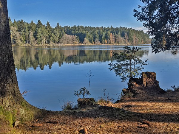
From here, it's just a short descent through the meadow to our sports rental Lipno Naplno and the Jestřábí camp, concluding this modest autumn trip. Now you deserve not only a hearty lunch or dinner but perhaps also a dip in the cooling reservoir. You can combine pleasure with utility and, after the cycling trip, refresh yourself in the invigorating water under the beautiful large tree, which is a renowned landmark of the Jestřábí camp.
GPS Coordinates:
Hodňov: N 48°46.94402', E 14°4.49392'
Olšina: N 48°46.81922', E 14°5.74480'
Osada Mokrá: N 48°45.50953', E 14°7.92518'
Lom Muckov: N 48°44.26217', E 14°8.60557'
Pláničský rybník: N 48°43.39110', E 14°9.33433'


